NORTH WEST
07. Cumbria Dentdale
Distance: 2.5 miles/4km | Time: 1.5 hours | Grade: Easy | Total ascent: 61m
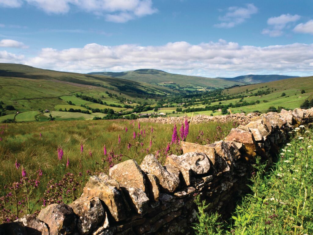
The Yorkshire Dales, which stretch into Cumbria, contain most of Britain’s surviving upland hay meadows, traditionally farmed to allow wildlife to thrive.
Dentdale is one of these valleys, divided into a patchwork of idyllic stone-walled fields colourfully blanketed in yellow, pink, white and purple wildflowers in spring and summer.
Starting from the charming narrow, cobbled streets of Dent, take time on this walk to look down on species such as meadow buttercup, eyebright and red clover, but also to gaze up at the lofty hills, rising to the highest points in both Yorkshire and Lancashire.
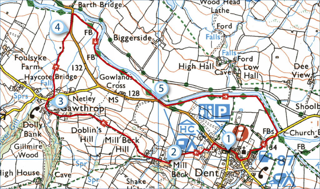
1. START
Turn right out of the pay and display car park in Dent village. After 109 metres, take the track on the left, signposted Gawthrop. On entering a caravan site, take a few steps left and then go right – beside the farm shed.
After a stile, walk with a wall on your right and through a gate. Swing up towards the farm.
2. 0.3 MILES
Go through a metal gate to pass between the buildings. Keep straight ahead – through two gates, still following signs for Gawthrop. As you wander across the meadows, views of the dale open out, with Aye Gill Pike on the far side of the valley.
Entering a second field, go straight across, later dropping through a small wall gate. Follow the boundary on the left to some farm buildings. Go through the two gates and head left to join a walled path. Turn right along a surfaced track and bear left at the next junction.
3. 0.9 MILES
Go right at the road for 45 metres and take the signposted path on the left. Head to the right of the buildings to enter an open area. Follow Oliver Gill downstream, the beck’s clear waters tumbling down over smooth bedrock.
After 200m, leave the gillside route by swinging right, beside a wall. Go through a small gate in the wall and turn right, continuing with the boundary on your right.
4. 1.1 MILES
Turn left at the road for 109 metres and then go through a tiny gate on your right. You now follow the Dales Way through charming riverside meadows where grass and wildflowers are left to proliferate until mowing later in July. Be sure to walk in single file through the meadows.
In a third meadow, swing half-right to reach the tree-lined riverbank. Follow the River Dee upstream to the road.
5. 1.7 MILES
Turn left for 82 metres and then take the trail on the left. Follow the riverside path until it re-emerges on the road. Turn right. Keep right through Dent village and the car park is on the right beyond the cobbles.
USEFUL INFO
Starting point
Pay-and-display car park, Dent village, LA10 5QP. S3 Western Dales Community Bus runs three services to Hawes a day, Monday to Friday.
Terrain
Rough tracks and meadow paths, some unclear. Several stiles. Some short road sections.
Map
OS Explorer OL02
Eat/drink
Stone Close Tea Room, Dent, is just 45 metres from the end of the walk. stoneclose.com
Stay
High Laning campsite has pitches for tents and caravans. highlaning.com