Pictures of Earth from space – Apollo images of our planet and beautiful close-ups from the Space Station
Restored images of Earth captured during the Apollo missions cast new light on the fragility of our planet.
By
Published: Friday, 27 September 2024 at 08:58 AM
The pictures of Earth against the blackness of space are perhaps the greatest legacy of the Apollo Program.
As Apollo 8 astronaut Bill Anders said on returning from the first voyage beyond Earth’s orbit: “We came all this way to explore the Moon, and the most important thing is that we discovered the Earth.”
‘Earthrise’, captured by Bill Anders during Apollo 8, and ‘The Blue Marble’, captured by the Apollo 17 crew, are not just famous pictures of Earth from space, they are among the most widely reproduced photos of all time.
Great Barrier Reef from space. Credit: NASA, M. Justin Wilkinson, Texas State U., Jacobs Contract at NASA-JSC
Apollo pictures of Earth from space
One of the most famous pictures of Earth from space, ‘Blue Marble’ was captured during Apollo 17 and revealed our planet as a beautiful yet fragile world. Click to expand. Credit: NASA
Apollo pictures of Earth from space remain the most eye-catching.
The contrast of the delicate blue and white sphere with the inhospitable void and barren Moon became the iconic image for the growing environmentalist movement.
And the image of a world without borders helped people see a world more united than divided.
But why haven’t Apollo pictures of Earth from space, great as they are, been bettered by others since then?
A key reason is that since the Apollo Program, astronauts have got no higher than low-Earth orbit – less than 1% of the way to the Moon.
Taking a photo of Earth from there is like taking a portrait of a friend with the camera less than a centimetre from their face.
Apollo 12 astronaut Alan Bean pictured with one of the famous Apollo Hasselblad cameras used to capture pictures of Earth from space, mounted on his spacesuit, 20 November 1969. Click to expand. Credit: NASA
You might be able to capture the texture of their skin, but any attempt to render their entire face would be distorted.
And while some of the autonomous spacecraft destined for other worlds turned their sensors around for a parting shot, their cameras weren’t designed for the job, producing inferior images.
In contrast, as the Apollo astronauts travelled out towards the Moon, they reached the perfect distances for capturing pictures of Earth from space.
NASA had provided some of the world’s best equipment for photographing Earth: Hasselblad 500 EL cameras, Zeiss lenses and 70mm Kodak Ektachrome film.
They were thus able to faithfully record Earth’s true colours as they appeared to the human eye.
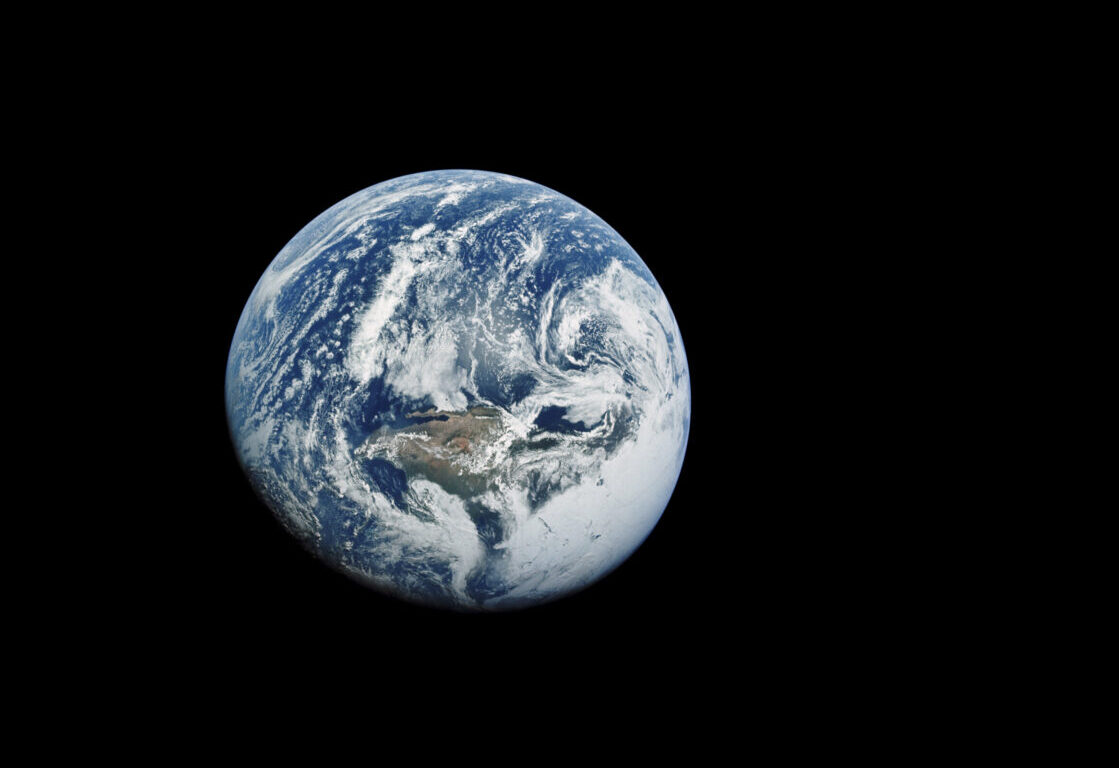
A remarkable view of Earth from Apollo 16, taken on 16 April 1972, reveals a world of blue and white with a hint of brown. Click to expand. Credit: NASA / Toby Ord
If we look at this image from Apollo 16 (above), what we see isn’t the bright green and blue circle that has come to represent our planet.
Instead, it is primarily a world of blue and white, with brown continents and just a suggestion of muted green in places of lush vegetation:
“I was able to look out the window to see this incredible sight of the whole circle of the Earth,” said Apollo 16’s Charlie Duke.
“Oceans were crystal blue, the land was brown, and the clouds and the snow were pure white. And that jewel of Earth was just hung up in the blackness of space.”
Restoring Apollo Earth photographs
A lesser-known crescent earthrise, captured during Apollo 12 on 19 November 1969. Click to expand. Credit: NASA / restored by Toby Ord
Struck by the beauty of the most famous of these Apollo pictures of Earth from space, I wondered if there were more.
So began a journey that would occupy my evenings over the next three years.
I hunted through all 18,000 Hasselblad photos from the Apollo missions for the best images that time forgot, and digitally restored them to bring out their full glory.
It was these lost images of Apollo that were the real rivals to the most well-known ones.
One of my favourite hidden gems is the crescent earthrise from Apollo 12 (above).
It was captured by Richard Gordon as he circled the Moon alone in the Command Module, awaiting his companions’ return.
It was overlooked for years as the original negative was poorly exposed and washed out.
But as soon as I properly adjusted the levels, it took my breath away, revealing a haunting scene with an even more graceful and fragile view of the Earth and Moon than Apollo 8’s famous ‘Earthrise’ photo.
I chose it for the cover of my book The Precipice, which looks at humanity’s own fragility in these challenging times.
Another one of my favourite pictures of Earth from space is from Apollo 13.
Two days in, the craft suffered a dramatic explosion, venting the contents of the Service Module’s oxygen tanks into space, leaving the Command Module without enough breathable air to get home.
This ethereal photo (below), at first appears to show the Moon, but it is really the crescent Earth amidst the ghostly reflections of the Lunar Module.
They were 80,000km and seven hours away from safety – this photo captures this stolen moment, yearning for home.
A haunting view of a crescent Earth taken from inside Apollo 13’s Lunar Module on 17 April 1970. Click to expand. Credit: NASA / restored by Toby Ord
It was an absolute treat to be able to play a role in reviving these images. There are so many more great photos that have never been restored.
But, since raw scans of all the images are publicly available, anyone can try their hand.
The last image of the whole Earth taken by a human being, during Apollo 17, 17 December 1972. Credit: NASA / restored by Toby Ord
Apollo 17 was the last crewed mission to the Moon, or as astronaut Gene Cernan would have put it, the ‘most recent’ crewed mission to the Moon. This crescent earthrise was captured on 16 December 1972. Credit: NASA / restored by Toby Ord
An Apollo 15 earthrise, 4 August 1971. It may not seem it, but this image in in colour. The lunar surface is at the top of the image and Earth is below it, perhaps giving a more accurate depiction of the sensation of spaceflight. In space, there is no ‘up’! Credit: NASA / restored by Toby Ord
A black and white earthrise captured during Apollo 14, 7 February 1971. When this image was taken, the astronauts were returning from the far side of the Moon on their journey home. Credit: NASA / restored by Toby Ord
A crescent Earth surrounded by reflections of the Lunar Module during Apollo 13. The Lunar Module became the Apollo 13 astronaut’s only hope of survival once the Command Module lost power. This image was captured 3 days after the explosion on 17 April 1970. Home must’ve seemed a very long way away. Credit: NASA / restored by Toby Ord
Apollo 12 slips out of Earth’s shadow, and the eclipse comes to an end. The astronauts can now see the Sun shining from behind Earth’s silhouette, 24 November 1969. Credit: NASA / restored by Toby Ord
An attempt to capture a total eclipse of the Sun by the Earth with a long exposure during Apollo 12, 24 November 1969. A glowing ring of atmosphere can be seen around Earth, but the thin circle is blurred by hand shake and a camera malfunction has spread the light vertically across the image. Credit: NASA / restored by Toby Ord
Apollo 11 astronaut Michael Collins captured this image of the Lunar Module carrying Neil Armstrong and Buzz Aldrin back up to the Command Module after the mission that made them the first humans to step foot on the Moon, 21 July 1969. Credit: NASA / restored by Toby Ord
A slightly more obscure image of our home planet, captured by Apollo 11 astronaut Buzz Aldrin during the first crewed moonlanding. Earth as seen from the Lunar Module before it separated and descended to the surface of the Moon, 20 July 1969. Credit: NASA / restored by Toby Ord
North America and the Pacific can be seen clearly in this view of Earth captured during Apollo 10, 18 May 1969. Credit: NASA / restored by Toby Ord
Bill Anders’ famous colour earthrise shot, captured during Apollo 8, 24 December 1968. Credit: NASA / restored by Toby Ord
The first earthrise photo, captured by Apollo 8 astronaut Bill Anders moments before his more famous colour shot, 24 December 1968. Credit: NASA / restored by Toby Ord
The moment human beings saw the disc of Earth against the blackness of space with their own eyes. This image was captured during Apollo 8, 21 December 1968. Credit: NASA / restored by Toby Ord
A view of the crescent Earth captured by an automatic camera during the Apollo 4 mission, 9 November 1967. Credit: NASA / restored by Toby Ord
A haunting view of a crescent Earth, as taken from inside Apollo 13’s Lunar Module on 17 April 1970. Credit: NASA / restored by Toby Ord
A lesser-known crescent earthrise, as captured from Apollo 12 on 19 November 1969. Credit: NASA / restored by Toby Ord
A remarkable view of Earth from Apollo 16, taken on 16 April 1972, reveals a world of blue and white with a hint of brown. Credit: NASA / Toby Ord
Modern pictures of Earth from space
Since the Apollo era, pictures of Earth from space are captured by satellites and astronauts onboard the International Space Station.
These images are captured too close to Earth to encompass the entirety of our planet’s globe, but instead they offer more detailed views of individual cities, countries, continents and natural phenomena.
You can see some of our favourites below.
The Great Barrier Reef captured by astronaut Kjell Lindgren from the International Space Station. Credit: NASA
Image of the Great Barrier Reef off the east coast of Queensland, Australia, captured by the Envisage satellite on 18 May 2008. Credit: ESA
Great Barrier Reef from space. Credit: NASA, M. Justin Wilkinson, Texas State U., Jacobs Contract at NASA-JSC
View of the Grand Canyon from space captured by former NASA astronaut Terry Virts, 29 December 2019. Credit: NASA
Snow at the Grand Canyon, as seen from space. Image captured by an astronaut onboard the International Space Station, 29 December 2018. Credit: SS Crew Earth Observations Facility/Earth Science and Remote Sensing Unit, Johnson Space Center.
This labelled image of the Grand Canyon from space shows Lake Mead, the Colorado River and Lava Falls. It was captured by NASA’s Landsat 8 satellite on 29 March 2013. Credit: Satellite image by Robert Simmon, using Landsat data from the U.S. Geological Survey and NASA.
Former NASA astronaut Jeff William captured multiple images from the International Space Station that were used to create this mosaic showing the Grand Canyon. Credit: NASA
Grand Canyon from space captured by the European Space Agency’s Envisat satellite. Credit: ESA
Image of Earth captured by the European Space Agency’s Juice spacecraft during a flyby on 20 August 2024.
Image of Earth captured by the European Space Agency’s Juice spacecraft during a flyby on 20 August 2024.
Labelled image of Europe at Night from space, including London, Paris and Amsterdam. Credit: International Space Station (ISS) Crew Earth Observations Facility and the Earth Science and Remote Sensing Unit, Johnson Space Center
A satellite image showing Europe from space. Credit: NASA/Goddard Space Flight Center
An image of Earth captured from the International Space Station by Samantha Cristoforetti, 20 March 2015. Back on Earth, Europeans enjoyed the sight of a partial solar eclipse. Credit: ESA/NASA
“Been some great night passes over Europe recently…I am waving!” – Tim Peake captured this image from the International Space Station
Ed White became the first American to perform a spacewalk during the Gemini 4 mission on 3 June 1965. Credit: NASA
A view of Earth and our Moon captured from Mars orbit by the Mars Global Surveyor on 8 May 2003 at 13:00 UTC. Credit: NASA/JPL-Caltech/Malin Space Science Systems
The Colorado River in southeastern Utah, captured by an astronaut onboard the International Space Station. Credit: SS Crew Earth Observations Facility / Earth Science and Remote Sensing Unit, Johnson Space Center.
A view of the Indian Ocean from space, captured in June 2021 from the International Space Station. Credit: NASA
Image of Ibiza captured by an astronaut on the International Space Station. Credit: NASA/William L. Stefanov, Jacobs/ESCG at NASA-JSC.
Photo of the Richat Structure, or the Eye of the Sahara, in Mauritania, captured from the International Space Station on 10 July 2020. Credit: NASA
Photo of the Richat Structure, or the Eye of the Sahara, in Mauritania, captured from the International Space Station by astronaut Nick Hague in Septemebr 2019. Credit: NASA
Area 51 from space. A satellite image of the area in Southern Nevada, USA. Photo by Gallo Images/Orbital Horizon/Copernicus Sentinel Data 2024
A view of northeastern USA at night, from space, including cities Washington, Philadelphia, New York and Boston. Credit: NASA/JSC Gateway to Astronaut Photography of Earth.
A view of the 10/11 May 2024 aurora display over the USA from space. Credit: NASA Earth Observatory image by Wanmei Liang, VIIRS data from Suomi National Polar-orbiting Partnership. Photo by Gunjan Sinha.
A view of the Soyuz capsule and aurora over Earth, captured from the International Space Station by ESA astronaut Thomas Pesquet, featured in his book The Earth in Our Hands. Credit: Firefly Books
An image of the aurora over Earth, as seen from the International Space Station on 26 June 2017. Credit: NASA
The aurora appears over Moscow, imaged by astronauts on board the International Space Station.
Aurora over Earth, as seen from the International Space Station. Credit: NASA
Aurora appears above Earth, photographed from the vantage point of the International Space Station.
Aurora australis as seen by the International Space StationISS, 13 August 2021IMAGE CREDIT: NASA
Earth from space: the Red Sea Coast of Saudi Arabia captured from the International Space Station. Credit: NASA/ESA
ESA astronaut Alexander Gerst captured this image from the International Space Station on 19 June 2018. Gerst said “I think I finally found the answer to a question I’ve been asked a 1000 times. Can we see the Great Wall of China from the ISS? Credit: ESA
Sunrise from space, captured from the International Space Station as it orbited 264 miles above Shenzhen, China. Credit: NASA
Earth and the Pacific Ocean from space, as seen from the International Space Station. Credit: NASA
Progress 80 cargo craft departs the ISSInternational Space Station, 23 October 2022Credit: NASA
The Pyramids of Giza, photographed during the International Space Station Expedition 32. Credit: NASA
This breathtaking photo of Ireland was captured by former NASA astronaut Terry Virts on 13 March 2015 from the International Space Station. The clouds seem to have parted to enable Virts to get the shot, just 4 days ahead of St Patrick’s Day. Easily discernible in the northeast of the island is Lough Neagh, located in Northern Ireland and the largest freshwater lake on the whole island.Also visible in the image are the curvature of the Earth and solar panels providing solar energy to the ISS.Credit: NASA/ESA/Terry Virts
Credit: ESA/NASA
Credit: ESA
NASA astronaut Peggy Whitson pictured in the Cupola section of the International Space Station. Credit: NASA
A photograph of the area where the asteroid that created the Chicxulub crater and is buried beneath the Yucatán Peninsula in Mexico. This photo was captured by astronaut Tim Peake while onboard the International Space Station. Credit: ESA/NASA
Sunrise from orbitInternational Space Station, 25 May 2022Credit: NASA
Bright lights of the UK at night, as seen from the International Space Station. Credit: MarcelC / Getty Images
ESA astronaut Samantha Cristoforetti points her camera out the Cupola on the International Space Station to capture an image of Earth. Credit: ESA/NASA
The rising Sun shines through the solar arrays of the International Space Station. Credit: NASA
Fires in Argentina, from the ISS International Space Station, 28 June 2020. Credit: NASA
The city lights of western India and Pakistan spread across the subcontinent like a glittering web as the International Space Station orbited 261 miles above.
Space Shuttle Endeavour delivered the US-built Unity module to the International Space Station on 6 December 1998. It was the first piece of the ISS to be provided by the US. Credit: NASA
Astronaut Robert Curbeam works on the International Space Station’s S1 truss during Discovery’s STS-116 mission, December 2006. Credit: NASA
Space Shuttle Endeavour docked to the International Space Station. Credit: NASA
The coastline of Florida, Cuba and the Bahamas, captured by Tim Peake on board the International Space Station.
An image of Doha, the capital city of Qatar, in a photo taken from the International Space Station. Credit: NASA
The International Space Station orbits the Earth so fast that it’s only in the sky ay any one place for a few minutes. Credit: NASA
Space Shuttle Atlantis docked to the International Space Station during STS-132. Credit: NASA
GPS provides altitude and positional navigation for the International Space Station. Credit: NASA/Roscosmos
The International Space Station imaged by an STS-131 astronaut on Space Shuttle Discovery, 17 April 2010. Credit: NASA